Observing the Sound
Monitoring the pulse of the Sound
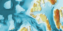
There is a rich history of oceanographic observations in Puget Sound. The PRISM marine modeling program is making extensive use of these for model validation and regional scientists have been using the data for a variety of purposes, including studies of change due to climate or human activity in the Sound.
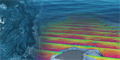
Since 1998, PRISM cruises have been undertaken throughout greater Puget Sound, roughly every 6 months. Volunteer students help PRISM scientists to measure well-resolved sections of CTD data and other bio-chemical properties down the axis of the Main Basin, Whidbey Basin and Hood Canal. These PRISM cruises visit many of the same stations visited by some of the earliest Puget Sound measurements gathered in the Collias Atlas (Collias et al., 1974). Another key regional data set is the repeat stations monitored by the Washington State Department of Ecology (DoE) since the 1970s. The DoE stations consist of several dozen locations around Puget Sound and the coastal estuaries where monthly CTD casts have been made over recent decades.
A third key data set is JEMS (Joint Effort to Monitor the Strait). Since September 1999, monthly cruises have occupied three hydrographic stations south of San Juan Island. These data, although monthly, provide more realistic boundary conditions for circulation models than the use of climatological data. These data are critical for understanding the properties of water flowing into and out of Puget Sound. The current funding for JEMS is through the Washington Department of Ecology, UW - PRISM, and UW – Friday Harbor Laboratories.
Collectively, these extraordinary data sets have proved invaluable both for validation of the PRISM-MoSSea circulation model, and also for studies of climate effects in the Sound (e.g., Moore et al., 2008). Similar data from our Canadian colleagues at IOS provides CTD data in Georgia Strait, which is within the MoSSea model domain, and helps to provide a regional view. All of these data streams can be obtained from NANOOS, the Northwest Association of Networked Ocean Observing Systems through their NANOOS Visualization System (NVS) for data.
PRISM research scientists and modelers also make use of more intensive data sets from numerous research projects, many of which involve PRISM scientists, and are focused on specific topics. Among these are two studies involving sewer outfalls, the LOTT study in Budd Inlet and the Brightwaters study near Edmonds, a project discerning the causes of hypoxia (low oxygen) in Hood Canal, the Hood Canal Dissolved Oxygen Program (HCDOP) in Hood Canal, ongoing studies evaluating tidal energy in Admiralty Inlet, research on physical flow dynamics at Three Tree Point, on biophysical dynamics in Carr Inlet (MIXED study), and several Canadian campaigns in Juan de Fuca.
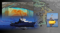
While cruise data are invaluable, technological advances now enable real-time observations using autonomous buoys, drifters, and gliders. Two federal programs, the Ocean Observing Initiative (OOI) and the Integrated Ocean Observing System (IOOS) are fostering increased observing capability in the Pacific Northwest. NANOOS is the PNW Regional Association for the NOAA-funded IOOS and is serving real-time data from numerous observing assets in Puget Sound, including the ORCA buoys now in Hood Canal, as well as other moored sensors throughout the Sound. UW is working with partners to make the Puget Sound buoy network more extensive. The NSF-funded OOI will have a Coastal Endurance Array with moorings and gliders on the Washington and Oregon shelf, continuously reporting data in real time. Together, these two programs will deliver key data on the coastal ocean waters that feed Puget Sound. Currently, such data is available primarily through cruises from projects such as RISE and ECOHAB. These only cover 2003-2006, but they have excellent measurements of biological and chemical properties which will be important for the MoSSea ecosystem modeling work.
In the near future, these real-time ocean "observatory" measurements will be combined with the MoSSea model to create ongoing forecasts, similar to those made for weather. Also, as sensor technologies increase, remote monitoring of chemical events, like oil spills detected by optical sensors, and biological dynamics, such blooms of harmful algae detected by genetic sensors or passage of fish detected by acoustic sensors, will be available. PRISM is well networked regionally to use these data for advances in science, education, and regional planning.