Water Cycle of Puget Sound
Effects of a century of land cover and climate change on the hydrology of the Puget Sound basin
PRISM, in partnership with the UW Climate Impacts Group (CIG) is conducting a series of studies investigating the interplay of changing landscapes and climate on the distribution of water (the “hydrology”) across the Puget Sound. This work is based on the application of DHSVM (Distributed Hydrology Soil Vegetation Model), a geospatially-explicit, process-based model. DHSVM can be used as a time machine, to look backward in time, to diagnose current conditions, and to look into the future, through developing scenarios. Because DHSVM is based on physical first-principles of how the landscape functions, it has greater freedom to explore possible outcomes than more classic, statistically-based tools.
As our time machine, DHSVM was used to provide a comprehensive evaluation of the concurrent effects of land cover and climate change on the hydrology of the Puget Sound basin in the post-settlement era. Anglo settlement of the Pacific Northwest dates to the mid-1800s, which is fairly recent compared to much of the North American continent. Since that time, the land cover of the region, which once was mostly coniferous forest, has changed dramatically as the population has grown. In the first 100 years or so of the post-settlement era, the major land use conversion was associated with forest harvest. Some areas have undergone several cycles of forest harvest and regrowth. Especially over the last half century, expansion of the major metropolitan areas, such as the Everett-Seattle-Tacoma corridor of western Washington, has resulted in conversion of substantial portions of the landscape from forest to urban and suburban uses. Concerns have been raised about the effects of ongoing land use change on various aspects of the hydrologic cycle, including summer low flows, groundwater recharge, and flooding.
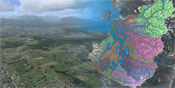
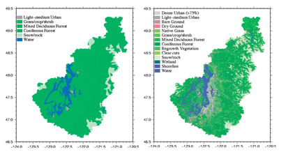
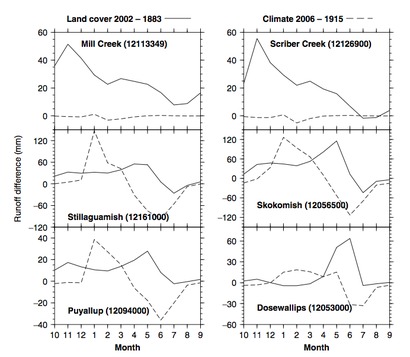
To evaluate the potential consequences of landuse and climate change over the last century, Cuo et al (2009) focused on the period 1915 to 2002, during which the quality of climatological data is sufficient to infer hydrologic changes. With respect to land cover, the study period goes back to 1883, the earliest time for which we could obtain credible land cover data. The study is summarized here, The analysis was based on a comparison of landcover from 1883 and from 2002 (Fig. 1). Climate data were reconstructed from National Climate Data Center (NCDC) records. Simulations of different combinations of landcover and climate change were run.
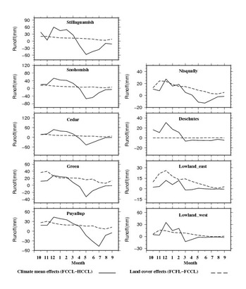
The model simulations suggest that in the highly urbanized lowland sub-basins, land cover change has been the dominant factor controlling hydrologic change. Current land cover results in higher fall, winter and early spring streamflow but lower summer flow compared to historic land cover. It also, in general, produces higher annual maximum flow and annual streamflow than historic land cover, although the predicted change is largely within the variability of observation for the upland basins. In upland areas, both climate change and land cover change appear to be important factors. Temperature change effects occur primarily through their influence on snow. Basins with much of their area at intermediate elevations are more sensitive to temperature change than those in either lowland or high elevation zones. Temperature change mainly affects seasonal streamflow distribution, not annual streamflow amount in the upland basin. See Fig. 2 for land cover and temperature change impacts and the comparison.
We now move to the present, more urban, landscape. Urbanization modifies hydrological processes by replacing vegetated land cover with impervious surfaces and by extending the natural drainage network to include artificial ponds, ditches and conduits laid on the ground and underground. Impervious surfaces reduce infiltration, generally resulting in increased surface runoff and reduced base flow. Artificial ditches and conduits alter runoff pathways and change stormwater drainage. In urbanizing catchments, surface flow may be diverted to artificial ponds or flood detention ponds built to reduce flood risks or in some cases for irrigation purposes. To describe such landscapes, DHSVM had to be modified (Cuo et al 2008). The study lays a foundation for land cover change studies in the broader Puget Sound basin, where urbanization is largely mixed with other land cover (e.g., forest).
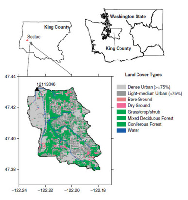
This work is summarized here. Briefly, To account for urban hydrological processes, a land cover category “urban” was added to the model. For pixels with this land cover type, a fraction of impervious surface area is also specified. The fraction of impervious area determines the amount of surface runoff generated on impervious surfaces. For the fraction that is not impervious, DHSVM handles infiltration using the same parameterizations as for non-urban pixels. A second parameter called the fraction of water stored in flood detention was also added. These two parameters allow the model to mimic, in a qualitative way, the dominant processes in urban runoff, specifically surface runoff generation and detention storage. For testing purposes, Springbrook Creek near Orillia, southwest King County, was chosen, because it is a partially urbanized basin, is relatively small, and hourly precipitation data from a nearby climate station are readily available (Fig. 3).
Following model testing, the overall effects of urbanization were investigated, showing that urbanization increased both seasonal and annual streamflows substantially. The largest increases occurred in the winter and the smallest increases were in the summer. Application of the model to a partially urbanized catchment in the Puget Sound drainage showed that using physically realistic values of impervious surface, fraction of impervious runoff routed to detention, and detention drainage parameters, resulted in good matches with observed flows. Simulations without the effects of detention storage greatly overestimated observed peak flows.
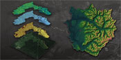
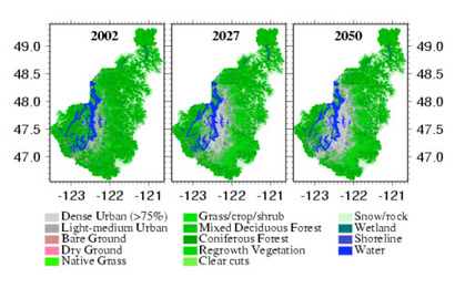
We now take our time machine into the future. Cuo et al (2010) used DHSVM to study the potential impacts of projected future land cover and climate change on the hydrology of the Puget Sound basin in the mid-21st century. Projected climate conditions for the mid-21st Century were represented using statistically downscaled climate ensembles from the 2007 Intergovernmental Panel on Climate Change (IPCC) 2007 study, while 2050 land cover was projected from a previous forecast of 2027 land cover (Fig. 4, Hepinstall et al. 2008). Results are summarized here (Fig. 5). In general, the climate change signal on hydrology, which was evidenced primarily through changes in timing of winter and spring runoff, exceeded that of land cover in upland basins, which are snow-rain mixed or snow dominated in the current climate. In contrast, projected changes in land cover were generally more important than climate change in those lowland basins where the projected land cover change from non-urban and partially urban to urban was substantial. Projected land cover change in the urbanizing portions of the Puget Sound lowlands generally lead to higher runoff in fall, winter and spring, and reduced evapotranspiration as a result of the combined effects of increased impervious area and reduced vegetative cover.
Cuo, L., D.P. Lettenmaier, B.V. Mattheussen, P. Storck, and M. Wiley. 2008. Hydrological prediction for urban watersheds with the Distributed Hydrology-Soil-Vegetation Model, Hydrologic Processes 22(21):4205-4213 . DOI: 10.1002/hyp.7023.
Cuo, L., D.P. Lettenmaier, M. Alberti, and J.E. Richey, 2009. Effects of a Century of Climate and Land Cover Change on the Hydrology of the Puget Sound Basin, Hydrologic Processes. 23 (6), 907–933). DOI: 10.1002/hyp.7228
Cuo, L., Beyene T., Voisin N., Su F., D.P. Lettenmaier, Alberti M., J.E. Richey, 2010. Mid-21st Century Climate and Land Cover Change Effects on the Hydrology of the Puget Sound Basin, Washington, in review, Hydrological Processes.