Landcover of Puget Sound

The Puget Sound region is a dynamic landscape. Bounded by sub-alpine meadows of the Cascade and Olympic mountain ranges, the Puget Sound ecosystem transitions through numerous terrestrial and aquatic ecoregions. Changes in these regions occur on a variety of spatial and temporal scales; from precipitation and land surface runoff to biogeochemical cycles, which relate to the productivity of our landscape and habitat selection by various species.
Regional land cover analysis is one of the key building blocks for explaining and modeling impacts of development patterns on interconnected biophysical elements and ecological processes throughout the Greater Puget Sound Region. Results are useful for multiple stakeholders, including PRISM, which uses land cover as one of the central data layers for modeling watershed hydrology using DHSVM. A central question is: how does land cover and land use change on a yearly to decadal basis, under different growth and climate scenarios?
Initial PRISM work to construct land cover classifications was led by Miles Logsdon, based on data from 1998 LANDSAT (using a PRISM-sponsored class to do the work). The resulting product was used not only in PRISM, but by multiple agencies throughout the region. Following this work, PRISM supported a project by the UW Urban Ecology Research Lab (UERL), led by Marina Alberti, to produce a detailed regional land-cover classification for the year 2002. This work was used in a series of hydrology papers by Cuo et al. It also supported UERL’s agenda to analyze time-series, land-cover development patterns in the Central Puget Sound Region, building on land cover products that now span nearly twenty years (e.g., Alberti et al. 2004). The project helped lead to a series of grants, including a study of biocomplexity funded by NSF.
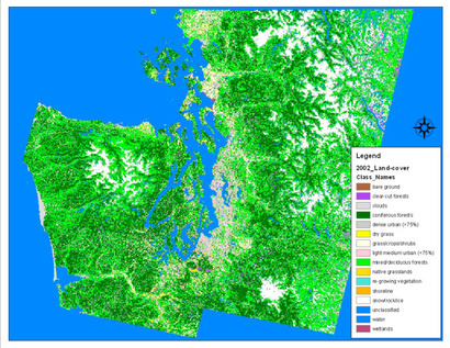
For the 2002 landcover work, Landsat TM and ETM+ imagery covering the extent of the greater Puget Sound region was acquired, including four summer and four winter scenes in 2001 and 2002. These images then underwent extensive processing to produce the final classifications. The final image (Fig. 1) uses the following classifications: dense urban (>75% urban); light-medium urban (<75%); bare ground; dry grass; native grasslands; grass/crops/shrubs; mixed/deciduous forests; coniferous forests; re-growing vegetation; clear-cut forest; snow/rock/ice; clouds; wetlands; shoreline; and water.
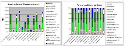
Land-cover classes by area (square km) and percent land-cover were summarized for each of the twelve Washington counties fully covered by the spatial extent of the image data (Whatcom, San Juan, Skagit, Island, Snohomish, Jefferson, Kitsap, King, Grays Harbor, Mason, Thurston and Pierce). (Fig. 2)
Major products resulting from the 2002 Land-cover Analysis of the Greater Puget Sound Region include 1) geometrically and radiometrically corrected Landsat TM and ETM+ seasonal images for 2002 covering the spatial extent of the Greater Puget Sound Region; 2) seasonal change and NDVI images; and 3) a 15-class, land-cover classification image resulting from a complex, hybrid methodology for multi-dimensional image classification. Scientists, analysts, students, policy-makers and data-modelers will apply these products for a variety of environmental and spatial analyses, to include the furthering of inter-disciplinary program goals to explain and model impacts of urban development patterns on interconnected biophysical elements and ecological processes occurring throughout the Greater Puget Sound Region. Likely next steps include follow-on methods to improve accuracy and interpretation of this land-cover product, methods for improving NDVI change analysis using seasonal images, and the implementation of this product to future analysis of time-series, regional land-cover change detection and modeling.


